

"How bowed the woods beneath their sturdy stroke.'" — Gray.
BEFORE the rear-guard of the savages had left the Territory of Illinois,
their pale faced foes were seeking lodgment in the present precincts of
Pulaski County. In a preceding chapter, we have a thrilling account of a
massacre of a number of defenseless whites by a band of Indians, near Mound
City, as an evidence that the Anglo-Saxons were, here as elsewhere, treading
upon the red man's heels, and as elsewhere, but shared the fate of man^^ of
their ancestors, as a penalty of their temerity. We have not, in all cases,
been blameless in our contests with the Indians. The most insignificant "
worm of the dust " will sometimes turn when trampled upon, and the "
untutored savage," with the provocation of being deprived of his lands,
often without any remuneration, can scarcely be censured, by the
unprejudiced mind, for his attempts to punish the despoilers. Driven step by
step from the homes of his fathers, he has almost reached the end of his
wanderings, and from the peaks of the “rockies" he "reads his doom in the
setting sun." As Sprague says, "he must soon hear the roar of the last wave
which will settle over him forever." Yes, we have often been the aggressor
in our "discussions" with the Indians, and much of the punishment we have
received at his hands was richly merited. The very full and complete history
of the county given in the preceding chapters, leaves but little to be said,
without indulging in repetition, in the individual precincts. All the
principal points of historic interest have been gone over, and the progress,
growth and development of the different portions of the county fairly and
truthfully written. A few words, however, will be devoted to each precinct
in this chapter, by way of conclusion of our work.
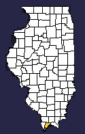
Burkville Precinct.— This is the smallest division of the county, and with
Mound City Precinct forms its southern extremity. It contains some fine
land, and could it be fully protected from inundation, it would, with
artificial drainage, would prove as fine a farming region as can be found in
the State. It is mostly rich bottom, but the danger from overflow renders
much of it comparatively valueless. It is bounded on the north by Villa
Ridge Precinct on the east by Mound City Precinct, and on the south and west
by the Cache River. The timber growth is that common in the bottoms in this
portion of the State, with a heavy undergrowth.
Owing to the nature of the ground, its low level surface, it was not settled
as early as other sections of the county. No settlements were made until
after the Emporium Company had commenced operations at Mound City, if we
ma}' except an occasional squatter. But since the building of the Central
Railroad, the land has been mostly taken up, and a number of enterprising
people have settled within its limits. No doubt the time is not far distant,
when, by our Yankee achievements, Burkville Precinct will become the very
garden of Pulaski County.
The Village of Burkville was laid out by William Burke May 25, 1858. It is
situated on the west half of the southeast quarter of Section 22, Township
16 and Range 1 west. It is the junction of the Mound City division of the
Illinois Central Railroad, but as a town its pretensions are modest in the
extreme, and half a dozen houses are all there is of it, except the
side-tracks of the railroad. The Beech Grove and Catholic Cemeteries are
located a little north of the village — one on each side of the railroad,
and but a short distance apart. There are but one or two schoolhouses in the
precinct, owing to the sparse settlement.
Villa Ridge Precinct. — This is one of the most thickly settled, as well as
productive portions of the county. It is a fine fruit-growing section; in
fact, fruit and vegetables are its chief products. There are few points on
the Central Railroad from which are shipped more fruit and vegetables than
from Villa Ridge. The land of the precinct is high and rolling, verging into
hills on both sides of the railroad, and is well adapted to fruit culture.
The timber is principally oak, walnut, hickory, maple, gum, ash, etc., etc.
The land is drained by a number of small streams which flow into Cache
River. Villa Ridge is bounded on the north by Pulaski Precinct, on the east
by Ohio and Mound City Precincts, on the south by Burkville Precinct, and on
the west by Cache River. The Illinois Central Railroad passes nearly through
the center with a station at the town of Villa Ridge. Taken altogether, it
is a fine neighborhood; the people are thrifty, energetic and intelligent,
and are rapidly growing wealthy. The Atherton settlement was one of the
first made, not only in this precinct, but in the present limits of the
count}-. Aaron Atherton was the pioneer, and came from Kentucky, probably as
early as 1816, and settled west of Villa Ridge Station, a community that is
still known as the Atherton Settlement. There were nine families of the
Athertons and their relatives that came here together, and about the same
time. The first church in the county was organized here, and probably the
first burying ground was laid out in this settlement. The church was known
as the Shiloh Baptist Church, and was organized in 1817, and is said to have
been the second church established in the State. James Edwards and Thomas
Howard were instrumental in its formation, and it still exists as a monument
to their Christian piety. The first building was a hewed log house. In time
it was replaced with a large frame, which was afterward burned. The present
building is a frame; the present pastor is Elder T. S. Low.
There are several other church organizations in Villa Ridge Precinct. A
church called the Seventh Day Baptist stands about two and a half miles east
of the village, and was organized about 1869. Elder Cottrell was the first
pastor. The church building is a frame, and was erected some ten years ago
at a cost of $650. A flourishing organization of Good Templars, known as
Meridian Lodge, No. 94. meets in the church. It was formed about six years i
ago, and is still doing good work in the temperance cause. The colored
people have a Methodist Church and also a Baptist Church in this precinct.
The Baptist Church is in the grove near the village. Rev. A. J. Johnson is
pastor of the Baptist Church, and is noticed further in Pulaski Precinct.
The Methodist Church is located northwest of the village, and is called
Chapel Hill.
Villa Ridge has been laid out as a village in installments. A part of it,
but whether the first part of it the records do not say, was laid out by
William Harrell, April 17, 1866, on the southeast quarter of the southeast
quarter of Section 34, Township 15, and Range 1 west. Another part was laid
out by the same party on the northeast quarter of the northeast quarter of
Section 3 of Township 16, and Range 1 west. The record of this addition
gives no date. A place called Salem was laid out on the hill above Villa
Ridge, but has been vacated.
Villa Ridge is the shipping point for a fine fruit-growing section, and
large quantities of fruit and vegetables are shipped from here every season,
as will be seen from the chapter on agriculture and horticulture. It is also
a place of considerable business, having several stores, mills, shops, etc.
It has suffered a great deal from fires during the past two or three years,
so much so that insurance companies, we learn, withdrew their policies. A
Masonic lodge, entitled Villa Ridge Lodge, No. 562, A.,F. & A. M. was
organized here June 22, 1867, with J. H. Lufkin, Master. A Methodist Church
was organized here at an early day and for a long time held their meetings
at different places in the neighborhood. About the year 1870, efforts were
commenced to build a house, and as soon as a sufficient amount of money
could be raised, the present church was erected at a cost of about $1,000.
It was dedicated in 1871. and is a substantial frame building. A union
Sunday school is maintained with a good attendance.
Ohio Precinct. — This precinct contains some fine farming land. It borders
on the Ohio River and lies directly north of Mound City Precinct. The land
is somewhat rough along the river, rising into bluffs in places, but back
from the river it is a high tableland, lying well, and is adapted to grain
and fruit. The fruit business, however, has not received the attention here
that it has in other portions of the county. Much of the precinct was
originally heavily timbered, but this is fast disappearing before the march
of progress. It is bounded north by Ullin and Grand Chain Precincts, east by
Grand Chain and the Ohio River, south by Mound City Precinct, and west by
Villa Ridge and Pulaski Precincts.
Among the early settlers of this precinct were Enoch Smith. Thomas Forker,
the latter a Magistrate and a man of considerable prominence; Nathan M.
Thompson, also a prominent man"; Capt. James Riddle and others. Capt. Riddle
was the father-in-law of "Parson" Olmstead, as his friends all call him, and
was a man of energy and of the finest business abilities. He built the house
where Mr. Olmstead now lives, and owns a great deal of land, amounting to
several thousands of acres, in this and Alexander Counties. He was one of
the first traders to New Orleans, and followed boating for years, and ran
one of the first steamboats to New Orleans. A native of Pennsylvania, he
lived several years in Kentucky, and was one of the original proprietors of
the town of Covington in that State, but came here in an early day. But so
much is said of him in a preceding chapter that it is unnecessary to repeat
it. Mr. 01mstead himself is not a new-comer here, but has been in the county
nearly half a century, and is well acquainted with its history. From a
centennial sketch of Pulaski County written by him and published in the
Cairo Argus, in 1876, many important facts in this part of our work have
been obtained. He lives in the little village which bears his name, and
having nearly reached the end of life's journey, he stands among his
fellowmen, highly respected by all.
The old town of Caledonia was laid out by Capt. Riddle and John Skiles,
after the abandonment of America. It was at one time quite a business place,
but upon the death of the proprietors, its progress was arrested, and in
1861, it was vacated by act of Legislature. Among the early settlers and
business men of old Caledonia were John Worthington, Sr., William A. Hughes
and Hugh and Isaac Worthington, all of whom are now deceased.
North Caledonia was laid out on land owned by Col. Justis Post, on Section
26, and the south half of Section 23. all in Township 15 and Range 1 east.
The plat was surveyed July 7, 1843, and submitted to record September 6,
following. Col. Post made a donation of land for a court house and other
county buildings. It was afterward increased and enlarged by the Winnebago
Land Company, and at one time was a flourishing town. But the building and
opening of the Illinois Central Railroad drew its trade to other points, and
it has since declined in
prosperity, until at the present time it is almost wholly deserted. The town
of Napoleon is a thing of the past. It was once a village of this precinct,
but not a vestige of it now remains.
The little village of Olmstead was laid out E. B. Olmstead, September 9,
1872, on the northwest quarter of the northeast quarter, and the northeast
quarter of the northwest quarter of Section 27, and the southwest quarter of
the southeast quarter of Section 22, all in Township 15 and Range 1 east. It
contains a dozen or so of houses, two or three stores and a few shops. The
Cairo and Vincennes Division of the Wabash Railroad passes through it, and
its station here is the shipping point for a large scope of country.
A number of churches in the precinct afford the people ample religious
facilities. There is a Presbyterian Church at the old town of Caledonia; a
Southern Methodist Church at the Center Schoolhouse, and a Colored Methodist
Church two or three miles north of Olmstead. The precinct has some four or
five good, comfortable school houses, in which schools are taught for the
usual terms each year.
Pulaski Precinct. — Next to Villa Ridge Precinct, Pulaski pays more
attention to fruit than any division of the county. Its topographical
features, except a small portion of the northwest corner along Cache River,
which is somewhat swampy, partake of the same nature of Villa Ridge, being
high, rolling and hilly, with plenty of timber of the kinds common to the
county. The precinct is bounded north by Ullin Precinct; east by Ohio, south
by Villa Ridge, and west by the Cache River. It has the advantage of the
Illinois Central Railroad as a means of communication with the outside
world. Settlements were not made in Pulaski as earl}as in many other
portions of the county. The Lackey settlement was perhaps the first in the
precinct made by white people. Thomas Lackey, a North Carolinian, came here
about 1823, and still has a number of relatives and descendants living in
the vicinity. At the time, however, of building the Central Railroad, nearly
the entire precinct was a thick, unbroken wilderness. But since that great
thoroughfare was opened, it has settled to a considerable extent, and is
developing rapidly into a fine farming and fruit-growing region.
The village of Pulaski was laid out and the plat recorded March 28, 1855. It
is located on Section 15 of Township 15, and Range 1 west. Abraham A. Perley
and Egbert E. and Henry Walbridge were the original proprietors. The latter
two gentlemen were among the leading business men of the place, and under
the name of Walbridge Brothers, carried on a large trade. Lumber has always
been the largest and most profitable interest, and man}saw mills have from
time to time been in operation, turning out immense quantities of lumber,
which finds its way to market over the Central Railroad. Several stores here
do a flourishing business. The post office was originally called Walbridge,
but has been changed to Pulaski. A. W. Lewis is the present Postmaster. The
vegetable business was commenced here about 1867, and has since grown to
large dimensions.
The Mount Pleasant Baptist Church, located in the Lackey settlement, though
having a small membership, is in a very healthy state The colored people
also have a flourishing church on Section 24, and deserve considerable
credit for their zeal in religious matters.
In connection with this church, a few words are due to Rev. A. J. Johnson, a
man born a slave, in Clark County, Ky., August 18, 1818, to Col. J. D.
Thomas. By his own energy and industry, coupled with a native intelligence
superior to that of most of his race, he worked in the hemp business in
Kentucky, made money and purchased his freedom, paying to his master $800
for the same. He came to Illinois in 1857, and first stopped at Mound City,
but a few years later came to this precinct, where he has since resided, and
where he owns a well-improved farm. He has been in the ministry for
thirty-two years, first in the Christian Church, but upon coming to Illinois
he united with the Free-Will Baptists, and for the past seventeen years he
has had charge of the Villa Ridge Colored Baptist Church.
Education receives the attention of the citizens of the precinct, and a
number of comfortable schoolhouses attest their interest in this great
civilizing influence. Good schools are taught each year in all of the school
districts.
Ullin Precinct. — This precinct, like Pulaski, is comparatively new as
regards settlement. It is largely composed of bottom lands, which extend
from Wetaug into Pulaski Precinct. Cache River running through, and its
bottom spreading out over nearly the whole precinct, frightened the early
settlers from what they deemed its miasmatic swamps. It lies south of Wetaug
Precinct, north of Pulaski Precinct, west of Grand Chain Precinct, and east
of Alexander County. Since the building of the Illinois Central Railroad,
the precinct has been considerably settled. The lumber interest is the most
valuable industry and receives much more attention than agriculture. The
Legislature appropriated $1,000 at one time for improving the State road
through the bottoms of Ullin Precinct. This money was expended in grading
and corduroying the road, so as to render it passable at all times, when not
overflowed from high water.
The precinct is well supplies with churches, and the people have no lack of
church privileges. There is a Methodist Episcopal Church in the village, and
a Lutheran and Methodist Church in the precinct. There is also a Baptist
Church on Section 21 of the precinct. I Several comfortable schoolhouses
show the interest the people take in educational matters. Ullin Village was
laid out by D. L. Philips and J. F. Ashley, and the plat submitted to record
February 20, 1857. It occupies the southwest corner of Section 26, and a
part of Section 23, Township 14, Range 1 west. It is but a small place,
having but a hundred or two population, two or three stores and a few shops.
The lumber interest is large and valuable. The saw mills of James Bell are
the largest in Southern Illinois, and the piles of lumber cut annually by
them are simply immense. Mr. Bell ships millions of feet from these mills,
and still has plenty "more to follow." The mills are on the banks of Cache
River, by which stream great rafts of logs are brought to their doors, thus
saving the poor patient oxen many a hard pull.
The lime business has long been a valuable interest of Ullin Precinct. Of
this business, Mr. Olmstead says in his sketch: "The works of the Ullin Lime
& Rock Company are situated near Ullin. The quantity of pure blue limestone
is inexhaustible. The capacity of the kilns is three hundred barrels per
day. The lime is specially adapted to the manufacture of gas and glass, and
for building purposes it is excellent. Since 1866, the company has expended
$40,000 in improvements. There are twenty-five neat dwellings belonging to
the company, besides other buildings. The company furnish lime, slightly
damaged, in any quantity to farmers, and many are availing themselves of
this generous offer."
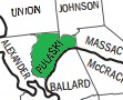
Grand Chain Precinct. — This division lies in the northeast corner of the
count}', having for its boundaries, Johnson County on the north, Massac
County on the east, the Ohio river on the south, and Ohio and Ullin
Precincts on the west. The name of Grand Chain was derived from the chain of
rocks which extend through the precinct, and across the Ohio River here. The
precinct, like Ohio, is a fine farming country, and some of the most
flourishing and productive farms and thrifty farmers in the county are to be
found here. The land is high and lays well, is gently rolling, except along
the river, which is quite rough and hilly. Originally the land was mostly
heavy timbered, and to open a farm was a work of great labor. From the
number of squatters who came in early, the community was christened "The
Nation" by Capt. Freeman, a name it long bore, and which is still often
applied to it. In the formation of Pulaski County this portion of its
territory was cut off" from Massac County. It is also told that during the
campaign upon the new county question, that this place again received the
name of The Nation. But although some of the first comers were men rather
rude and uncouth, the community has grown out of the backwoods period, and
in no portion of the county, nor of Southern Illinois, can there be found a
more intelligent and refined people, or a better and more honorable class of
citizens. Some of the early settlers were: Absalom Youngblood, William Cain,
the Crockers, Smiths, Bartlesons, Hugh McGee and others. These hardy
pioneers came here when the country was a wilderness, and by dint of great
labor and perseverance, succeeded in opening farms and rearing houses and
homes. A prior occupancy, however, was what was known as Wilkinsonville.
"Gen. Wilkinson," says Mr. Olmstead, " about the close of the war of 1812.
ascended the Ohio River with a large body of troops, and established himself
at the head of Grand Chain. He erected extensive buildings for barracks,
with large brick chimneys, the remains of which are still to be seen. Quite
a population gathered around the place, which in honor of the commander, was
called Wilkinsonville. From 200 to 400 graves mark the spot where citizens
and soldiers found burial. The last inhabitant was Mr. Cooper, the father of
Bonaparte Cooper.' This movement of Gen. Wilkinson is a little curious, and
has, perhaps, never been wholly accounted for. Why he would lead a body of
men to this spot, at the time he did, is something of a problem.
A Christian Church was built in the precinct, mostly by Mr. Porter, which is
used by all denominations, but the Christians, we believe, have the
preference. Tt stands near Grand Chain Village, but was built before the
village was laid out. The colored people also have a church organization
called Bethlehem Church. The precinct is well supplied with schoolhouses,
and education receives the warmest support of the people. Some half a dozen
good, comfortable schoolhouses are scattered over the precinct at convenient
distances, and are well attended during the school term.
The village of New Grand Chain was laid by Joseph W. Gaunt, Warner K.
Bartleson and David Porter, and the plat recorded October 31, 1872. It is
located on the southwest quarter of the northwest quarter, and the northwest
quarter of the southwest quarter of Section 32, Township 14, and Range 2
east. It is on the Cairo Division of the Wabash Railroad, about five miles
south of the county line, and is a small and unpretentious village, with a
few stores and shops. A large amount of shipping is done, the surplus
produce of a large tract of territory accumulating here for transportation
to the different markets of the country.
A village called Grand Chain was laid out near where the present village of
New Grand Chain is located, but we have no record of it. Cacheton was also
laid out as a town by John Butler, November 13, 1873. It was situated where
Oaktown Post Office stands, on the railroad, near the county line. February
17, 1875, it was vacated by law.
Wetaug Precinct. — This is the northernmost precinct of Pulaski County. It
partakes somewhat of the surface features of Ullin Precinct, which lies
south of it, in that it has a good deal of bottom lands, subject, more or
less, to overflow. It contains, however, considerable fine farm lands, and
many productive farms and prosperous farmers are to be found in this
section. The precinct is bounded north by Union County, east by Johnson
County, south by Ullin Precinct, and west by Alexander County, from which it
is separated by Mill Creek. There was, originally, considerable fine timber,
but much of it has been cut away and sawed into lumber.
One of the earliest settlements made in the county was in this precinct, and
was known as the Sower's Settlement. Henry Sowers was the pioneer of quite a
colony, who came from North Carolina. Sowers settled at the Big Spring, as
it was called, and which is now in the village of Wetaug in 1816. Among
those who gathered around him were: Judge Hoffner, Richard Brown, the Nally
family, the Dexters, William McIntosh, the Knupps, Levi Hughes and others.
Some of these are still living, and many of them have descendants here.
Judge Hoffner is still a resident of the precinct, and is one of the
prominent men of the county.
Educational and religious facilities of the precinct are ample, and the
people lack neither. In the village of Wetaug, there is a Catholic and a
Lutheran Church, both of which are flourishing. Preparations are making for
the building of a German Reformed Church in the village, and it will perhaps
be erected during the present year.
The village of Wetaug is rather a small place, containing perhaps not more
than a hundred or so of inhabitants. A store or two; a few shops and a large
flouring mill comprise its business. It is a water and coal station on the
Illinois Central Railroad, and is the only stop the fast mail train makes
between Anna and Cairo. We could find no record of when it was laid out as a
village.
| Union | Johnson | |
| Alexander |
 |
Massac McCracken KY |
| Ballard KY |